


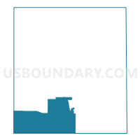
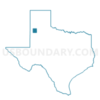
Voting District 0009, Lamb County, Texas
About
Outline

Summary
| Unique Area Identifier | 675366 |
| Name | Voting District 0009 |
| County | Lamb County |
| State | Texas |
| Area (square miles) | 116.64 |
| Land Area (square miles) | 116.02 |
| Water Area (square miles) | 0.62 |
| % of Land Area | 99.47 |
| % of Water Area | 0.53 |
| Latitude of the Internal Point | 33.87862770 |
| Longtitude of the Internal Point | -102.46420510 |
Maps

Graphs
Select a template below for downloading or customizing gragh for Voting District 0009, Lamb County, Texas


Neighbors
Neighoring Voting District (by Name) Neighboring Voting District on the Map
- Voting District 0002, Lamb County, TX
- Voting District 0004, Bailey County, TX
- Voting District 0006, Lamb County, TX
- Voting District 0008, Lamb County, TX
- Voting District 0010, Lamb County, TX
- Voting District 0011, Lamb County, TX
- Voting District 0032, Hockley County, TX
- Voting District 0033, Hockley County, TX
- Voting District 0034, Hockley County, TX
- Voting District 0043, Hockley County, TX
- Voting District 0101, Cochran County, TX
Top 10 Neighboring County Subdivision (by Population) Neighboring County Subdivision on the Map
- Levelland CCD, Hockley County, TX (18,238)
- Littlefield CCD, Lamb County, TX (7,301)
- Morton CCD, Cochran County, TX (2,450)
- Sudan-Amherst CCD, Lamb County, TX (2,222)
- South Sand Hills CCD, Bailey County, TX (420)
Top 10 Neighboring Place (by Population) Neighboring Place on the Map
Top 10 Neighboring Unified School District (by Population) Neighboring Unified School District on the Map
- Levelland Independent School District, TX (16,422)
- Littlefield Independent School District, TX (7,067)
- Sudan Independent School District, TX (1,503)
- Whiteface Consolidated Independent School District, TX (932)
- Whitharral Independent School District, TX (473)
Top 10 Neighboring State Legislative District Lower Chamber (by Population) Neighboring State Legislative District Lower Chamber on the Map
Top 10 Neighboring State Legislative District Upper Chamber (by Population) Neighboring State Legislative District Upper Chamber on the Map
Top 10 Neighboring 111th Congressional District (by Population) Neighboring 111th Congressional District on the Map
Top 10 Neighboring Census Tract (by Population) Neighboring Census Tract on the Map
- Census Tract 9501, Bailey County, TX (7,165)
- Census Tract 9502, Hockley County, TX (4,158)
- Census Tract 9505, Lamb County, TX (3,704)
- Census Tract 9506, Lamb County, TX (3,597)
- Census Tract 9501, Cochran County, TX (3,127)
- Census Tract 9503, Lamb County, TX (2,222)